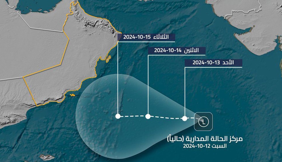

Muscat: The latest satellite images from the National Centre for Early Warning of Multiple Hazards reveal a tropical depression located at longitude 66.5 east and latitude 16 north, approximately 1,200 kilometers from the Dhofar coast. Forecasters predict the depression may intensify into a deep tropical depression over the next three days, moving westward toward the coast of Dhofar Governorate and the Gulf of Aden.
Starting the night of Monday, October 14, 2024, the depression is expected to bring increased cloud cover and rain to Dhofar, Al Wusta, and South Al Sharqiyah Governorates. Meanwhile, the northern governorates, including Muscat, South Al Batinah, and Ad Dakhiliyah, will also experience rainfall due to a low-pressure system affecting the region.
Monday, October 14, 2024
Read More
- Building completion in Oman to require telecom connection certificate under new rules
- Expat arrested over theft from commercial shop in Oman’s Bahla
- Oman exempts death cases involving citizens from healthcare service fees
- New Musandam road to cut Khasab–Dibba travel to 55 minutes for commuters in Oman
- Oman Across Ages Museum welcomes one million visitors
Expect cloud formation and varying rainfall intensities along coastal areas, particularly in the Southeastern, Central, and Dhofar Governorates. Rainfall is forecasted between 10-20 mm, which may cause rivers to swell. Winds will be active, with speeds of 15-20 knots (28-37 km/h), leading to low visibility during thunderstorms and possible dust due to downbursts. Wave heights along the Arabian Sea may reach up to two meters.
Tuesday, October 15, 2024
Cloud coverage will continue with varying rain intensities across South Al Sharqiyah, Al Wusta, Dhofar, and Muscat, South Al Batinah, and North Al Sharqiyah. Rainfall could range from 30-60 mm in southern regions, while northern areas may see 10-30 mm, increasing the risk of valley flows. Winds and wave conditions will remain similar to Monday.
Wednesday and Thursday, October 16-17, 2024
The trend of cloud formation and varying rainfall will persist, with potential thunder in southern and central regions, including South Al Batinah and North Al Sharqiyah. Anticipate rainfall between 20-40 mm, raising the likelihood of flowing rivers and valleys. Winds and wave conditions will continue to pose challenges, particularly during storms.





